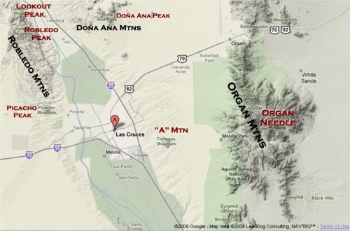
On the map, I've labeled the major peaks of the area (although I just realized I forgot to label Bishop's Cap- which is located at the very bottom of the image). The Organ Mountains have quite a few named peaks, so I only labeled the highest point (the Organ Needle).
There are three main mountain ranges in the area, or at least that people should be concerned with for hiking purposes:
The Organ Mountains, east of Las Cruces, are the most well-known. It’s probably one of the most popular backdrops to photos of the city and the area, and it’s generally hard to miss in town. I'll spend a good amount of time explaining the different peaks.
The Robledo Moutains are west of Las Cruces, essentially running north from Picacho Peak (another landmark of the area). In addition to Picacho Peak, there are two other major named peaks in this range, both in the northern part of the area by Radium Springs. The highest point in the range is Robledo Mountain. North of that is Lookout Peak (although I’ve also heard of it named “Signal Peak”).
The third major range in the area is the Doña Ana Mountains, north/northeast of Doña Ana. There are two major named peaks in the Doña Anas: Doña Ana Peak and Summerfold Mountain (not shown on the map- it’s a bit farther north, and more separated).
Another major range that might be worth pointing out is the San Andreas Mountains, which are the mountains directly north of the Organ Mountains, on the other side of US Highway 70. This range, however, is closed to public access. It's on a wildlife refuge, that is completely surrounded by White Sands Missile Range.


No comments:
Post a Comment