
...or truck, motorcycle, or any kind of auto-mobile.
I ended up selling my truck a few months ago. With that money, instead of trading it in for a new (or new-to-me) vehicle, I invested in a new bike. It's become my main source of transportation. I would not call it my "only" source, as I have feet and a unicycle. Having no car to cache with does make it things interesting sometimes, and frustrating at others.
While most of the time, city caches are easy to get to with a bike. I can ride anywhere within the city. Getting out on the dirt roads is also possible, but my bike is a hybrid (more of a mountain bike frame with tires similar to road tires- except a bit wider, but no traction). That hasn't stopped me completely, although it probably isn't the greatest on my tires (or me, since I'm bumping up and down, trying to control my bike while its attempting to skid around). Urban caches and some down dirt roads just outside the city. Easy. It'd work great if I was living in a bigger metro area, like Denver (unicycling worked great there).
In Las Cruces, at least since I've found many of the urban caches, it's not the greatest situation. If I want to go to one of the caches in the mountains, it'd require at least 20-25 miles of riding just to get to mountains and back. This doesn't include going on any trails, hiking. That'd be a tiring day, especially since there area few new caches on biking trails (biking to get to the head of the biking trial, plus biking down that, would be an exhausting day).
I don't want to complain about this- it's just a slight problem to overcome when geocaching. I think the best way to overcome it is to find more friends active in the outdoors who can do my level of activity. This includes mountain biking clubs (although I'd probably turn into a mountain cycling club- by being a unicyclist in a bicyclist-dominated area), search and rescue or hiking groups, etc. This way, when I want to go hiking or down a biking trail, I can plan a trip with others who want to do the same thing (and hopefully get a ride in the process).
In this sense, getting rid of my truck also gets rid of a lot of my solo adventures. Instead of going out and hiking, biking, unicycling, whatever, by myself, I'll be a little bit limited in what I can do alone and forced to interact with friends. At least that's what is planned for now.
10 August 2009
08 August 2009
First post of 2009
Whoops. Did I forget I had a caching blog? I suppose I did. This year started out a bit slow for caching, as I found myself with little free time. It's amazing what a full-time job will do for a caching career. With what little time I did have, I was also busy with various other groups, doing this or that. It seemed like every weekend, something came up. I do have more free time now, though. Last month, I took a trip to Denver. Since that trip, I've been doing quite a bit of caching. In fact, if I hadn't taken one day off of caching during that trip, I could have probably beat my record of most days cached in a row.
Also on that trip, I successfully started uni-caching: caching by unicycle. I knew my bike wouldn't be able to fit in the truck alongside everything else, but my unicycle managed to find a nice spot. It worked out to be a fun investment, and probably quicker than trying to walk around Denver between caching. Hopefully I'll try it out on some mountain cycling trails to see how it does off-road.
Besides that, I've also completed one more Labor of Hercules: The Organ Needle (Labor Eleven). That brings my total up to 11 of the 12 (plus the bonus cache). The only one I still need in the series is Labor Six: Florida Peak. I've tried that one before, but the group I was with decided against attempting the final ascent. I think I'd be nervous trying that one again, just because I know I turned around last time.
24 September 2008
Mountain Guide: Update and References
[Note: This originated from a post I wrote elsewhere, and I have decided it would be useful to post here, as well]
Back in July Earlier, I wrote a guide to the mountains of Las Cruces. I actually meant to follow that up with a little more detail of each of the mountain ranges, including access points, trails, and so forth. I still plan on doing that. I ended up getting distracted with other things (or just putting it off). In the mean time, I'd like to create a listing of other, similar, guides:
Book: Day Hikes and Nature Walks in the Las Cruces - El Paso Area, by Greg Magee
I've looked through this at Coas Books before, and I really like it. I think there's a fairly diverse group of places in here, so it's not all just mountain hiking. Some of the listings are off-trail, but there are quite a few trail listings as well.
Book: A Bark In The Park: The 45 Best Places to Hike with Your Dog in the El Paso/Las Cruces Region, by Jessica Powers (Amazon link)
I have not looked through this guide yet, but I found it on Amazon. The Table of Contents doesn't list what the 45 places are, so I can't judge on how diverse or great of a selection is included. From what I did see, however, there was at least a good introduction on taking a dog out hiking, especially going out into the desert. This book will most likely (a complete guess) be more focused on parks and trail systems in the area, with a tendency for more easier hikes than the Magee guide.
Website: Climbing Guide to the Organ Moutains, by R.L. Ingraham
This is an outstanding guide to more technical and difficult hikes/climbs in the Organ Mountains. Not all of the destinations listed here require rope and/or other technical skills, but quite a few do. The rest are fairly difficult hikes, mostly done without trails (or are non-managed, faded-out, and require bushwacking in spots). With that, this is a guide for getting to the top of many of the peaks in the Organ Mountains. If you want to see spectacular views, and love a challenge, this is a great guide.
Website: SummitPost page on the Organ Mountains
SummitPost.org is an all-around great source for climbing peaks, mountaineering, and other similar activities (lots of names apply to these). All the pages are written by other SummitPost users who have done these hikes in the past. After a page is put up, comments can be written with corrections to that if needed. This page covers some of the main peaks in the Organs, although not nearly as detailed as the Ingraham site. I think the SummitPost website is also more basic and easier to find what you need (since the Ingraham site doesn't have too many good pictures to help identify some of the locations, at least from what I found). To view individual peaks and trails in the Organs, use the menu on the left (under "Children").
There are probably quite a few more sources out there- please comment if you have any you'd like to mention. I'll probably update this entry as I get more references, instead of posting a new entry for each additional listing (just to keep everything together).
I've looked through this at Coas Books before, and I really like it. I think there's a fairly diverse group of places in here, so it's not all just mountain hiking. Some of the listings are off-trail, but there are quite a few trail listings as well.
I have not looked through this guide yet, but I found it on Amazon. The Table of Contents doesn't list what the 45 places are, so I can't judge on how diverse or great of a selection is included. From what I did see, however, there was at least a good introduction on taking a dog out hiking, especially going out into the desert. This book will most likely (a complete guess) be more focused on parks and trail systems in the area, with a tendency for more easier hikes than the Magee guide.
This is an outstanding guide to more technical and difficult hikes/climbs in the Organ Mountains. Not all of the destinations listed here require rope and/or other technical skills, but quite a few do. The rest are fairly difficult hikes, mostly done without trails (or are non-managed, faded-out, and require bushwacking in spots). With that, this is a guide for getting to the top of many of the peaks in the Organ Mountains. If you want to see spectacular views, and love a challenge, this is a great guide.
SummitPost.org is an all-around great source for climbing peaks, mountaineering, and other similar activities (lots of names apply to these). All the pages are written by other SummitPost users who have done these hikes in the past. After a page is put up, comments can be written with corrections to that if needed. This page covers some of the main peaks in the Organs, although not nearly as detailed as the Ingraham site. I think the SummitPost website is also more basic and easier to find what you need (since the Ingraham site doesn't have too many good pictures to help identify some of the locations, at least from what I found). To view individual peaks and trails in the Organs, use the menu on the left (under "Children").
There are probably quite a few more sources out there- please comment if you have any you'd like to mention. I'll probably update this entry as I get more references, instead of posting a new entry for each additional listing (just to keep everything together).
Mountains of Las Cruces: Introduction
I go hiking a lot in the mountains (often to the top of them). It can sometimes be difficult to explain to friends where exactly I'm going, however, since it has occurred to me people don't pay attention to the mountains as much as I do (and don't really know the different peaks). Not a problem! That's why I've decided to produce a nice little guide to the mountains around Las Cruces. I'll start with the basics in this post, and then move into more specifics (talking about each range in detail, and even a few peaks and hiking areas).
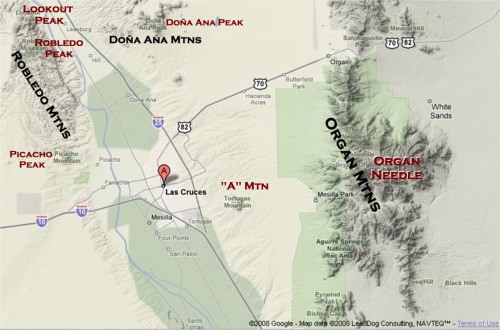
On the map, I've labeled the major peaks of the area (although I just realized I forgot to label Bishop's Cap- which is located at the very bottom of the image). The Organ Mountains have quite a few named peaks, so I only labeled the highest point (the Organ Needle).
There are three main mountain ranges in the area, or at least that people should be concerned with for hiking purposes:
The Organ Mountains, east of Las Cruces, are the most well-known. It’s probably one of the most popular backdrops to photos of the city and the area, and it’s generally hard to miss in town. I'll spend a good amount of time explaining the different peaks.
The Robledo Moutains are west of Las Cruces, essentially running north from Picacho Peak (another landmark of the area). In addition to Picacho Peak, there are two other major named peaks in this range, both in the northern part of the area by Radium Springs. The highest point in the range is Robledo Mountain. North of that is Lookout Peak (although I’ve also heard of it named “Signal Peak”).
The third major range in the area is the Doña Ana Mountains, north/northeast of Doña Ana. There are two major named peaks in the Doña Anas: Doña Ana Peak and Summerfold Mountain (not shown on the map- it’s a bit farther north, and more separated).
Another major range that might be worth pointing out is the San Andreas Mountains, which are the mountains directly north of the Organ Mountains, on the other side of US Highway 70. This range, however, is closed to public access. It's on a wildlife refuge, that is completely surrounded by White Sands Missile Range.
16 September 2008
Leave of Absence
As it turns out, I haven't been caching much lately. Some have noticed my lack of hides and finds. I haven't done any local caching. Most of the caching I have done within the past few months has been on vacations: San Francisco/Wheatland (for Geowoodstock) and Navajo Lake (camping with my family). I haven't forgotten or given-up caching, or replaced it with Waymarking. Life just gets in the way sometimes, forcing more important issues to be dealt with (amazingly enough, there are more important things than Geocaching in life... sometimes that can be hard to realize). I hope to get back into things soon, though (especially since it's starting to get less hot out).
24 June 2008
Caching dry spell
The last time I went without caching for about a month, a few of the local cachers noticed. Except for my Geowoodstock Trip at the end of May, I haven't been doing much caching lately. I think every cacher probably goes through "dry spells." For me right now, this includes transportation (gas, and my truck isn't in the best condition to do much driving), other things in life (trying to find a job), heat (summer in New Mexico limits caching severly - I don't want to do any all-day hikes when it gets to triple digits in the afternoon), and finally not many caches to choose from (I've found the majority of caches in the area, except for the more difficult ones I've had trouble with in the past, leaving me to travel for more unfound caches).
What does one do while in a dry spell? This is a chance to explore some "armchair caches," caches that can be done remotely (through a computer). This also lets me do some waymarking. Waymarking involves mostly taking photographs of sites, as well as recording the coordinates- which takes much less time than finding a cache. It can also be done easily while running errands: simply snap the photo.
It also leaves me a chance to plan for upcoming caches to place. I have one rather long multi-puzzle cache I've been planning, but just haven't had to time to fine-tune it. It will involve solving many puzzles and require traveling throughout the region to complete. I've also wanted to finish my "ABC's of Geocaching" series (which I'll describe in another blog).
For those with limited time, this could be a good chance to collect materials for caches. While cleaning around the house, for example, keep an eye out for what could be a good container. Organize your existing caching materials. If you want to actually go out and cache, this seems to be the reason a lot of urban caches exist. One common urban cache is the "lampskirt." They all are fairly easy to find, but do offer the chance to at least get out of the house and find a cache. Sometimes that's a nice feeling, just to get in the "caching zone" again.
02 June 2008
Geowoowoodstock VI

 Last week, I flew out to California for Geowoodstock VI. I spent most of my time on this week-long adventure between San Mateo and San Francisco to get use out of the free accommodation (my brother lives in the area). On Saturday, we headed out for Geowoodstock VI in Wheatland, just north of Sacramento.
It was amazingly fun. There were lots of geocaching-related vendors, selling geocoins, caches, GPS units, shirts, car accessories, anything that might be appealing to geoca
 chers. I'm amazed I didn't go into debt just from looking around. Throughout the day, there were many classes being offered, such as using a GPS unit, using a map and compass, various software programs (such as GSAK), hiking, etc. There were also lots of games, ranging from panning for gold to hunting for geocoins using a metal dector (that was fun). Geobingo was a bit of a challenge. You had to find cach
 ers who met certain criteria, such as having 5000 finds, being from out of state, caching since 2001, and so forth. I somehow managed to complete mine to get many raffle tickets. Music was playing throughout the day, and lots of interesting cachers were there waiting to be met (including one oddly green cacher).
One of the other interesting sites included the original can of beans, which was a trading item put into the first geocache. I'm not sure I'd want to eat any of thos
 e beans after this time, but it was at least interesting to see it,
Next year's Geowoodstock will be in Bell Buckle, TN, which is approximately an hour's drive from Nashville, according to Google Maps. It was certainly fun to attend with lots to do. I don't know if I'd set this as a high priority to attend another one, since I have a feeling the next one would be just like this. It's definitely worth going to once, though. I'm sure each one has it's own
 flavor and is equally fun, but once is enough to say I've been to Geowoodstock.
Subscribe to:
Posts (Atom)
